While a major part of the Himalayan region is susceptible to landslides, it is the high population density, major pilgrimage routes and tourism spots which has worsened the impact of disasters in Jammu and Kashmir, Himachal Pradesh and Uttarakhand
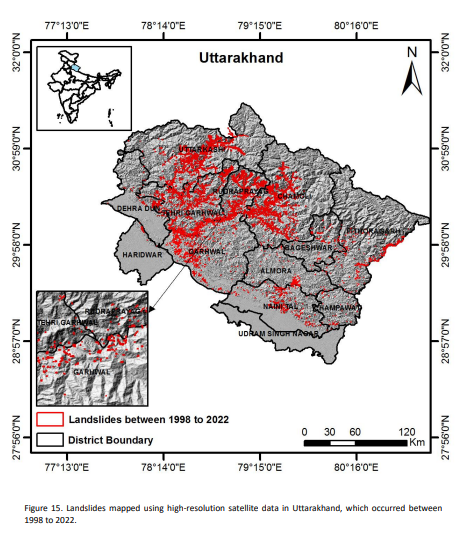
Rudraprayag and Tehri Gharwal of the Himalayan state of Uttarakhand have been the most landslide-affected districts over the last two decades, suggests satellite data captured by the Indian Space Research Organisation (ISRO). The region not only has the maximum density of landslides, but the highest exposure due to population.
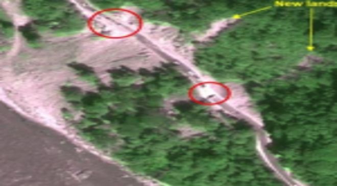
The findings emerged from the latest risk assessment done by scientists from Hyderabad-based National Remote Sensing Centre who created an all-India database of nearly 80,000 landslides that occurred from 1988 to 2022. The Landslide Atlas of India used the satellite data of ISRO to map all seasonal and event-based landslides like the Kedarnath disaster in 2013 and landslides triggered due to Sikkim earthquake in 2011.
147 AFFECTED DISTRICTS
The team used this information to rank the 147 landslide-affected regions in 17 states and two Union Territories for their landslide exposure in terms of key socio-economic parameters. According to scientists, the risk has further intensified over the years due to environmental degradation and extreme weather events which have increased due to climate change.
While a major part of the Himalayan region is susceptible to landslides, it is the high population density, major pilgrimage routes and tourism spots that have worsened the impact of disasters in Jammu and Kashmir, Himachal Pradesh and Uttarakhand. As many as 64 districts of Northeast too figured in the list, apart from southern states like Kerala which witness fewer landslides but face large destruction due to population density.
Thrissur (Kerala), Rajouri (Jammu & Kashmir), Palakkad (Kerala), Poonch (J&K), Malappuram (Kerala), south and eastern district of Sikkim and Kozhikode (Kerala) were listed among the 10 worst-affected districts, apart from the two Uttarakhand districts. It is for the first time that a pan-India rainfall-triggered landslide database has been readied, said the agency.
Read More: IMA says antibiotics for seasonal cold, cough will not work due to…
INDIA VULNERABLE TO LANDSLIDES
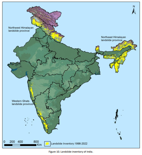
India is among the top four countries with highest landslide risk, with over 12.6 per cent of land area prone to hazard, excluding snow-covered areas. This covers the Himalayas, Western Ghats, Konkan Hills and Eastern Ghats of peninsular India which are highly susceptible to mass movements due to hilly topography and heavy rainfall events, which have been exacerbated by climate change.
In India, such disasters mostly occur in the monsoon season. Scientists say they can now identify the slow-moving mountain slopes because of the time series measurements from space using microwave satellite data and the InSAR technique which can detect displacement at the millimetre level.
However, predicting the flow path of that landslide and demarcating the release area which could be impacted still remains a daunting challenge.
The satellite and weather data is now being used to provide regional early warnings for selective routes of Himachal Pradesh, Uttarakhand and north-eastern states during the monsoons. These are based on rainfall threshold for landslides, which is the amount of rain which could trigger landslides in the areas.
The NRSC has also developed a mobile app — FLIM — to collect data of landslides from the field to develop a landslide warning system. The data collected by the app is uploaded in the BHUVAN and NDEM servers for analysis and visualisation, and issues alerts accordingly.