The radars will measure the earth in unprecedented detail every 12 days and empower scientists to track climate change over land and ice like never before, and also predict natural hazards like earthquakes
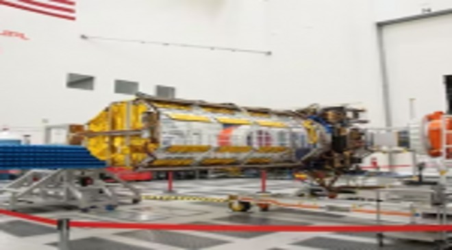
Jointly developed by scientists from the US and India, the much-awaited NASA-ISRO Synthetic Aperture Radar, or NISAR, has landed in India. The mega scientific payload was being integrated at NASA’s Jet Propulsion Laboratory in California.
Read More: Delhi liquor policy scam: Telangna CM KCR’s daughter summoned by ED
The Indian Space Research Organisation (ISRO) said the satellite had arrived in Bengaluru from the US on a USAF C-17. Its arrival has set the stage for the final phase of the mission, which involves its integration into the spacecraft bus. Now, ISRO will steer the final journey of the mission over the next few months before the satellite is cleared for launch in the first quarter of 2024 from Satish Dhawan Space Centre in Sriharikota.
The mega satellite consists of two separate radars. While the long range – L-band radar – has been developed by American scientists, the S-band radar was independently readied by their Indian counterparts in Bengaluru. Both were then transported to the Jet Propulsion Laboratory (JPL), where they were integrated into one unit. This has now been brought to India for the final launch aboard GSLV (Geosynchronous Satellite Launch Vehicle).
POWERFUL RADARS
The mission will map the entire globe every 12 days and capture places that have otherwise been obscured. The two radars will be connected with a mega drum-shaped antenna with a diameter of about 12, which is one of the largest that NASA has ever flown into space.
There are a lot of earth-observation satellites in space but NISAR has the capability to capture subtle changes on earth with unprecedented resolution and precision. The radars will give it the capability to see through dense cloud cover, day and night, for the next three years. It can even detect changes as small as 10 m.
MEASURE CLIMATE CHANGE IMPACT, PREDICT DISASTERS
Once the radar is placed in space next year, it will start collecting voluminous data of how the earth, including the land and ice sheets, are changing down to fractions of an inch. It will help in studying how fast ice sheets are melting, flow rate of glaciers, rise in sea levels and examine the impact of global warming. It will also be able to detect depletion in groundwater levels, and how much of it has affected nearby regions and if there is any sinking of the land.
The mission will also empower the scientific community with a massive amount of data that can be helpful in predicting the most challenging natural hazards – earthquakes, volcanoes and landslides.
The data, which can go up to almost 80 terabytes a day, can also be beneficial for agriculturists as the radar will provide high resolution data of soil moisture crucial for detecting early signs of droughts or wildfires.