The unusually warm Arabian Sea is now setting new records, churning multiple storms a year, with many of them like Cyclone Biparjoy surprising with their sheer intensity and unusually long lifespan
It took less than 48 hours for a low pressure system in the Arabian Sea to intensify into a large swirling storm. Within 12 hours, Biparjoy rapidly turned into a severe cyclone that continues to intensify six days after its genesis.
With powerful winds gusting up to 190kmph raging in the Arabian Sea, the cyclone is now charging towards the Indian coast to hit Saurashtra-Kutch on Thursday. The winds would drop to 150kmph by the time it hits the coast, but that won’t deter the gusty storm from damaging most vulnerable structures that lie in its path.
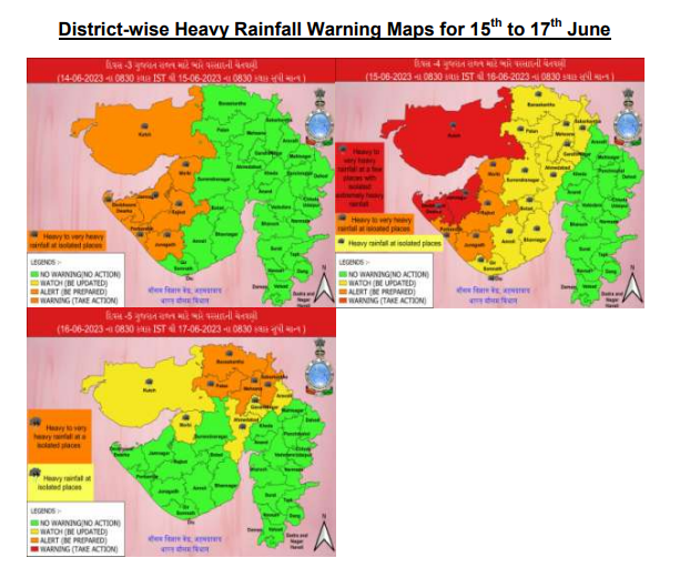
It would bring along very heavy rains for Gujarat’s coastal districts as it barrels its way into the mainland, preceding with storm surges of about 2-3 metres high. The low-lying areas would get inundated, crops damaged, houses destroyed and communication and power services impacted.
The very severe Cyclone Biparjoy is not the fiercest storm that the Arabian Sea has churned in recent years. In fact, the sea has produced two super cyclones in the last two decades – Gonu in 2007 and Kyarr in 2019. But Biparjoy has caught everyone’s attention with how quietly it has maintained its severe intensity for almost a week now.
Read More: Rozgar Mela: PM Modi To Distribute 70,000 Appointment Letters on Tuesday
“The cyclone has been moving slowly and drawing its energy from the warm sea. The conditions are quite favourable. It was time for the monsoon onset, and there was high humidity, and it continued to get stronger,” says Dr M Mohapatra, chief of IMD, whose team has been tracking the cyclone round the clock.
UNUSUALLY WARM ARABIAN SEA
Scientists monitoring the north Indian Ocean highlight how the Arabian Sea is “unusually warm”. The sea-surface temperatures have consistently risen since January, and hovered between 30-31℃ over central and south Arabian Sea.
“The sea has warmed by more than a degree over the last three months. The high heat potential is fuelling these storms, and it is definitely not as normal as one would expect. We are living in a warmer world, and we cannot rule out its impact,” says Professor Raghu Murtugudde from the Indian Institute of Technology (IIT), Bombay.
Scientists agree that it is not “very common” for cyclones forming in the Arabian Sea to maintain such intensity for so long. “It remained a severe cyclone for so many days now. Even though its intensity will reduce slightly by the time it makes landfall, it will still have the potential to carry widespread damage,” says senior scientist Dr M Rajeevan, who formerly helmed the Ministry of Earth Sciences.
Normally, Arabian Sea sees 1.7 cyclonic disturbances (depressions/deep depressions) every year, out of which, usually one develops into a cyclonic storm. But over the last few years, we have seen multiple storms forming along the west coast, with some of them intensifying into ‘severe’ ones.
Read More: Chandrayaan-3 to Be Launched Between July 12 and 19: ISRO Chief
In 2019, the Arabian Sea recorded its most intense cyclone season ever, with maximum cyclonic disturbances, and even twin cyclones forming at one point in time. Some recent studies led by scientists also show how the rising temperatures associated with global warming is also impacting the systems like Madden Julian Oscillation (MJO), which are linked to formation of tropical cyclones. Warm temperatures not only increase their intensity, but their lifespan.
Each cyclone is different from the other, and they are presenting newer forecasting challenges before the meteorologists every year. With a vast coastline of over 7,500 km, it is dire for the country to be prepared for such intense cyclonic storms. “The intensity of cyclones has undoubtedly gone up over the years. The west coast has seen intense cyclones in the past, but now it has become a yearly affair. Their severity is increasing, and some of them are rapidly intensifying,” says SC Shenoi, director of Hyderabad-based Indian National Centre for Ocean Information Services.
WIDESPREAD DAMAGE EXPECTED
Just 290 km from Porbandar in Gujarat on Tuesday morning, the storm has continued to move nearly northwards. After Wednesday morning, it is expected to veer towards the Indian coast and cross Saurashtra & Kutch and adjoining Pakistan coasts between Mandvi (Gujarat) and Karachi (Pakistan) near Jakhau Port (Gujarat) by the evening of June 15 as a very severe cyclonic storm.
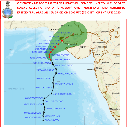
The dominance of two active anti-cyclonic circulations have led Biparjoy to change its path. But by the time it reaches near the coast, its intensity will reduce from ‘extremely severe’ to ‘very severe’ due to slightly lower temperature of the north Arabian Sea, and less humidity.
High waves have already begun to lash the coast of Gujarat, Maharashtra, Goa and Karnataka, and they may go up to 5-9 metres for Porbandar. The weather department has already sounded an orange alert for Saurashtra-Kutch and adjoining Pakistan coast and advised evacuation from coastal areas of Kutch, Devbhumi Dwarka, Porbandar, Jamnagar, Rajkot, Junagarh and Morbi districts.