Cyclone Biparjoy is expected to intensify into a very severe cyclonic storm and move north-northwestwards in the next six hours
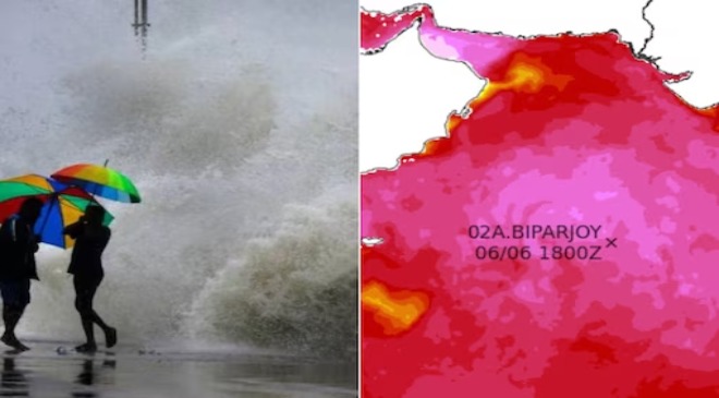
Cyclone Biparjoy, formed over east-central and adjoining southeast Arabian Sea at 11:30 pm on Tuesday near Goa, is expected to intensify into a very severe cyclonic storm and move north-northwestwards in the next six hours, India Meteorological Department said.
Read More: 80% Say Delhi, Punjab Govts Not Addressing Toxic Air Issues, Want Actionable Plans This Year: Survey
“Biparjoy formed at 2330 IST of 6 June near lat 12.5°N and lon 66.0°E, about 900km WSW of Goa. Likely to move nearly northwards and intensify into SCS during the next 6 hours,” the IMD said in its bulletin.
The cyclonic storm is likely to move north-northwestward towards Pakistan coast, with winds gusting up to 170kmph, the IMD said, adding that squally winds gusting up to 60kmph may be witnessed along and off the Karnataka-Goa-Maharashtra coasts during June 8-10.
A leading national daily quoting experts stated that ‘Biparjoy’ may not have a major impact on India’s west coast but it can further delay the onset of monsoon over Kerala by “driving away moisture”.
Read More: No Relief For Manish Sisodia As High Court Rejects Interim Bail Plea
The monsoon normally reaches the southern state by June 1. The southeast monsoon arrived in the southern state on May 29 last year, June 3 in 2021, June 1 in 2020, June 8 in 2019 and May 29 in 2018.
A report in Times of India quoted Roxy Mathew Koll, senior climate expert from Indian Institute of Tropical Meteorology (IITM), Pune, as saying: “Biparjoy is much away from the Indian coast as compared to Nisarga or Tauktae. This Arabian Sea cyclone will not affect the west coast directly, except some bursts of winds from a combination of cyclone gusts and background monsoon winds. But since it has formed over the Arabian Sea and is moving north-northwestward, it could drive the moisture away from India. This can hamper the onset and progression of the monsoon.”
News agency PTI, however, quoted scientists as saying a slightly delayed onset over Kerala does not mean that the monsoon will reach other parts of the country late. It also does not impact the total rainfall over the country during the season.
India is expected to get normal rainfall during the southwest monsoon season despite the evolving El Nino conditions, the IMD had earlier said. Northwest India is expected to see normal to below-normal rainfall. East and northeast, central, and south peninsula are expected to receive normal rainfall at 94-106 per cent of the long-period average of 87 centimetres.
Interestingly, a Twitter user, who claims to be a weather expert, said that three cyclonic systems are active in the Pacific at the moment — Chedeng that will affect parts of Japan, another storm that may make a landfall in China’s Hainan and Biparjoy that’s likely to affect India.
Read More: Millions Of Android Users’ Data At Risk! Dangerous Malware Found In Over 100 Apps – Check Out List
Philippines weather bureau on Tuesday said that ‘Chedeng’ has intensified into a tropical storm and may be upgraded to typhoon category by Thursday.
IMPACT OF CYCLONE BIPARJOY
• In the wake of the cyclone warning and rain forecast, the Nationalist Congress Party (NCP) has decided to postpone its Silver Jubilee celebrations, scheduled in Ahmednagar on Friday.
• Sea conditions are likely to be very high along and off the Kerala-Karnataka coasts and Lakshadweep-Maldives areas on June 6 and Konkan-Goa-Maharashtra coasts from June 8 to June 10. Fishermen out at sea have been advised to return to the coast.